
Scientists are tracking a developing El Niño in the tropical Pacific that could turn into the strongest event in 140 years. The phenomenon has already shown early signs and carries potential for major disruption to global weather patterns in the months ahead.
Paul Roundy, a professor of atmospheric and environmental sciences at the State University of New York at Albany, pointed to real potential for an extreme episode. His assessment comes as ocean temperatures begin to shift in ways that often precede intense El Niño conditions.
The World Meteorological Organization expects El Niño to emerge soon and persist at least into the Northern Hemisphere winter. Forecasters see it possibly peaking around September or October before stretching into next year.
El Niño develops when trade winds weaken or reverse. This allows unusually warm waters to build up in the central and eastern tropical Pacific near South America. The change alters atmospheric circulation and triggers widespread effects far from the ocean itself.
Regions in Central America, Africa, Asia and Australia often face hotter and drier conditions during such events. These can lead to severe droughts, strained water supplies, reduced hydropower and threats to agriculture. In contrast, parts of South America's Pacific coast typically see heavy rainfall and flooding.
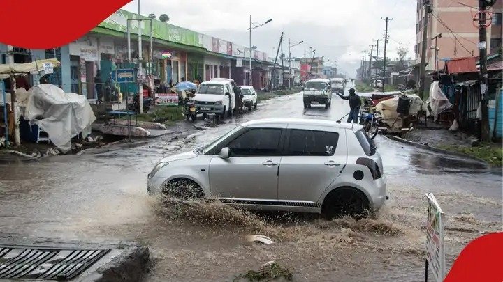
East Africa stands at particular risk of heightened flooding. The Indian monsoon may also weaken, affecting farming communities that depend on seasonal rains. Past strong El Niños have caused crop failures and left millions needing food assistance.
Experts note that global temperatures already sit near record highs. This El Niño could amplify the impacts of human-driven climate change. United Nations Secretary-General Antonio Guterres urged governments not to underestimate the threat.
The 2015-2016 El Niño brought economic and humanitarian costs in the trillions of dollars. Similar patterns this time could increase wildfire risks in Australia, Canada, the United States and the Amazon. The Atlantic hurricane season, however, may turn quieter due to increased wind shear.
Construction and infrastructure professionals in vulnerable areas have reason to monitor developments closely. Flood defences, water management systems and agricultural projects may need adjustments based on updated forecasts. Early warnings allow time to strengthen resilience measures.
Scientists emphasise that El Niño develops gradually. Monitoring of ocean and atmospheric conditions gives authorities months to prepare communities, safeguard harvests and improve emergency systems.
As models continue to refine projections, the focus remains on potential impacts in Kenya and across East Africa. The phenomenon has previously influenced rainfall patterns in the region, sometimes bringing excessive rains and flooding.
This latest alert adds urgency to discussions around climate adaptation in infrastructure planning. Engineers and policymakers watch for updates that could shape project designs and risk assessments in the coming seasons.
Comments (0)
Leave a Comment
No comments yet. Be the first to share your thoughts!