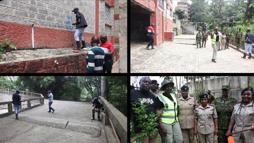

Yesterday a multi-agency team moved along the banks of Kirichwa Kubwa river to carry out riparian demarcation. The work covered the stretch running from Arboretum down to Kilimani, an area that mixes older residential plots with newer apartment blocks and commercial buildings.
Commissioner LeleiHon took charge of the operation on behalf of the Nairobi Rivers Commission. Officials from several government bodies joined the group, including security personnel who kept watch as the technical marking progressed.
On the ground the crew used standard field methods. They stretched measuring lines across concrete walkways and small bridges, then applied visible paint markers to adjacent walls and embankments. In one section blue lettering appeared on a red-painted retaining wall, indicating distances and reference points.
Kirichwa Kubwa forms part of the upper Nairobi river basin. The tributary flows through densely settled neighbourhoods where unregulated building has long pressed against the water’s edge. Demarcation of this kind draws clear lines between the river corridor and nearby land uses.
The exercise helps enforce existing planning rules that keep structures away from the waterway. It also reduces the risk of further pollution and eases pressure on natural drainage during the rainy seasons that regularly flood low-lying parts of the city.
Multi-agency coordination has become the standard approach for this type of work. Representatives from national environment agencies, county planning departments and law enforcement bodies work together so that the boundaries carry official weight once marked.
By the close of the day the team had outlined the protected zone for the full stretch. The physical markers now stand as reference points for any future construction permits or inspections in the vicinity. Property owners and developers operating near the river will need to factor the new lines into their plans.
The Nairobi Rivers Commission has made similar demarcation runs on other tributaries in recent years. Each outing builds a clearer picture of where development can safely occur and where the river must be left room to breathe.
Work like this often feeds into larger urban infrastructure decisions. Road upgrades, stormwater drains and riverside public spaces all become easier to design once the riparian reserve is physically defined on site.
Local residents who live along the route saw the team at work. Some paused to watch as ropes were pulled taut and paint applied. The visible activity serves as a reminder that the commission’s restoration mandate reaches into everyday neighbourhoods rather than remaining a desk exercise.
At the end of the session officials gathered for a brief group photograph before leaving the site. The commissioner’s presence throughout underscored the priority the commission places on hands-on implementation.
The marked stretch now joins other sections already completed across the basin. Over time these connected boundaries are expected to support more coherent management of Nairobi’s entire river system.
Comments (0)
Leave a Comment
No comments yet. Be the first to share your thoughts!