
The International Space Station is preparing to receive a specialized piece of African-built orbital infrastructure this Monday evening. Following a successful launch on Saturday afternoon, the ClimCam, an AI-enabled climate camera, is scheduled to dock with the station at 7.50 pm. This arrival follows a precisely timed departure from Earth at 1.41 pm East African time, marking a coordinated effort between the space agencies of Kenya, Egypt, and Uganda.
Engineers and scientists from the three nations designed the payload to address specific environmental challenges facing the Nile Basin. The hardware represents a tangible shift in how regional governments gather data for agricultural and disaster management. By utilizing artificial intelligence, the camera can process images in real-time, which helps in identifying rapid changes in land use and water levels.
The project highlights a growing trend of intra-African cooperation in the high-tech sector. While traditional construction often focuses on ground-level infrastructure, the deployment of such orbital assets is becoming a critical component for planning future terrestrial projects. Data from this camera will likely influence how irrigation systems, dams, and urban expansions are mapped out across the participating countries.
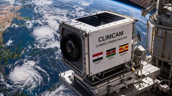
Elvis Ondieki, reporting on the development, noted that the arrival at the "heavenly destination" follows years of technical planning and cross-border partnerships. The three flags of Egypt, Kenya, and Uganda are prominently displayed on the side of the compact ClimCam unit. This visual serves as a reminder of the shared technical resources required to maintain a presence in low Earth orbit.
Operationally, the camera will provide high-resolution imagery that was previously only available through the purchase of data from foreign commercial satellite operators. By owning the payload, these nations gain direct control over the frequency and focus of their observations. This autonomy is vital for monitoring the effects of climate change, which continues to impact construction and agricultural schedules in East Africa.
Once the docking procedure is complete, the station's crew will manage the installation of the camera. The technical teams in Cairo, Nairobi, and Kampala will then begin the calibration phase to ensure the AI systems are communicating correctly with ground stations. This phase is crucial for the long-term viability of the data collection mission.
For the construction and engineering sectors, the integration of space-based data into project lifecycles is no longer a luxury. Having precise, updated visuals of terrain and weather patterns allows for more accurate site assessments. This reduces the risks associated with building in areas prone to flooding or soil erosion, which are increasingly common concerns in the region.
The mission also serves as a proof of concept for future African-led hardware deployments. As the ISS continues to serve as a platform for global research, the inclusion of East African technology demonstrates a rising proficiency in aerospace engineering. The successful integration of this camera into the ISS systems will likely pave the way for more complex joint ventures in the coming decade.
Comments (0)
Leave a Comment
No comments yet. Be the first to share your thoughts!