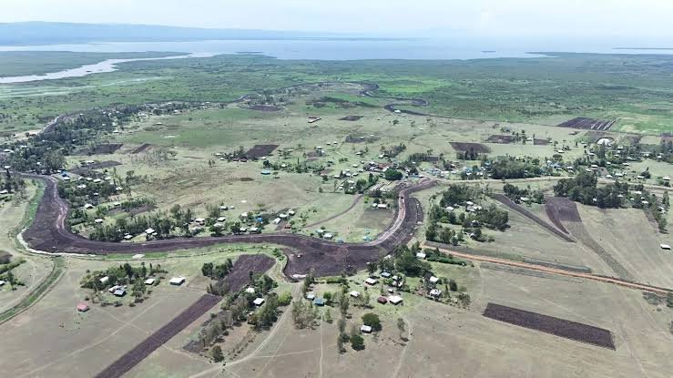

The National Water Harvesting and Storage Authority (NWHSA) is advancing civil works on the West Kano–Kanyagwal Flood Control Project in Kadibo Sub-county, Kisumu County. The infrastructure works protect local communities, and secure agricultural production after decades of seasonal devastation.
Located within Ogenya Sub-location, the low-lying plains along the River Nyando delta face severe flooding from river bursts and Lake Victoria backflow. Recent extreme weather displaced 684 households, and destroyed 450 houses in Kanyagwal, prompting this engineering response.
The civil engineering works focus on reclaiming nearly 7,000 hectares of flood-ravaged land. A central component of this initiative is a 1.5-metre-high flood protection dyke stretching 3.5 kilometres, designed to contain rising waters, and shield vulnerable settlements, markets, and schools.
Contractors are also executing comprehensive rehabilitation of drainage systems across the Kadibo area. Over time, heavy silting along the Wang' Nyando channel prevented water from draining into Lake Victoria, but engineers are desilting these lines, and upgrading pumping infrastructure.
To ensure long-term structural stability, the project incorporates extensive environmental restoration. Large-scale grassing and tree planting are underway along the reclaimed sections. This biological reinforcement stabilises the soil, and protects earthen embankments from heavy surface runoff.
Beyond flood mitigation, the infrastructure safeguards the 2,230-acre West Kano Irrigation Scheme. The scheme, managed by the National Irrigation Authority (NIA), remains a critical hub for regional rice production, but it has historically suffered severe seasonal crop losses.
By securing these agricultural fields, nearly 1,000 local farmers can cultivate their land with greater confidence. This protection allows households to maintain consistent crop cycles, and invest in agribusiness, when local weather patterns fluctuate.
A community footbridge is being built under the corporate social responsibility (CSR) framework. This structure ensures that residents, including school children, can safely cross over low-lying areas to access schools, health facilities, and local markets, when heavy rains occur.
The national government, through Interior Principal Secretary Dr Raymond Omollo, noted that the infrastructure forms part of a broader climate resilience plan. A local maintenance committee will oversee the dyke, conducting inspections every six months to ensure functionality.
Many families currently living in temporary tents and rescue centres are eager to return home. The completion of this dyke infrastructure represents a shift toward permanent safety, and economic recovery for the flood-weary residents of the Kano Plains.
Historical data indicates that the flat terrain of the Nyando Basin accelerates water accumulation, which frequently inundates critical public roads. The newly reinforced dyke alignment follows engineering assessments aimed at redirecting peak flows away from domestic zones.
Local administration officers are collaborating with the community to ensure smooth execution of the civil works. This joint approach minimizes land disputes, and speeds up the delivery of essential infrastructure, although schedules remain tight.
The upgraded pumping systems utilize modern automated valves to discharge overflow back into the lake. This mechanical intervention reduces water stagnation periods, which previously caused waterborne health risks, and halted economic activities for months.
Agronomists expect rice yields to double once the protected acreage is fully utilized by the local cooperative societies. Stable water levels will allow for double-cropping, expanding food security across Kisumu County, and creating rural employment.
Comments (0)
Leave a Comment
No comments yet. Be the first to share your thoughts!